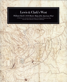
Lewis & Clark's West Collector's Edition
WARNING
You are viewing an older version of the Yalebooks website. Please visit out new website with more updated information and a better user experience: https://www.yalebooks.com
William Clark's 1810 Master Map of the American West
William Clark
In May 1804, Meriwether Lewis and William Clark began an expedition that fundamentally changed Americans' conception of their country. Clark drew dozens of maps and interviewed Indians to create rough charts of areas he did not visit. In 1810, after he returned to St. Louis, he created a comprehensive map of the West that opened a new era in American cartography. Clark's master map came to Yale University in the 1940s. At the bicentennial of the Lewis and Clark Expedition, the Yale Collection of Western Americana is pleased to make available a full-size, color facsimile of the manuscript map that transformed American history.
ISBN: 9780300134049
Publication Date: January 1, 2004
Publication Date: January 1, 2004
1 pages, 32 x 52

